Meteorologists say winter storm system could bring snow, ice to parts of Alabama, plunge whole state into deep freeze
A potential winter storm system moving into Alabama this weekend could bring dangerous icing to parts of the state, and forecasters say residents in our area should use the next few days to get ready.
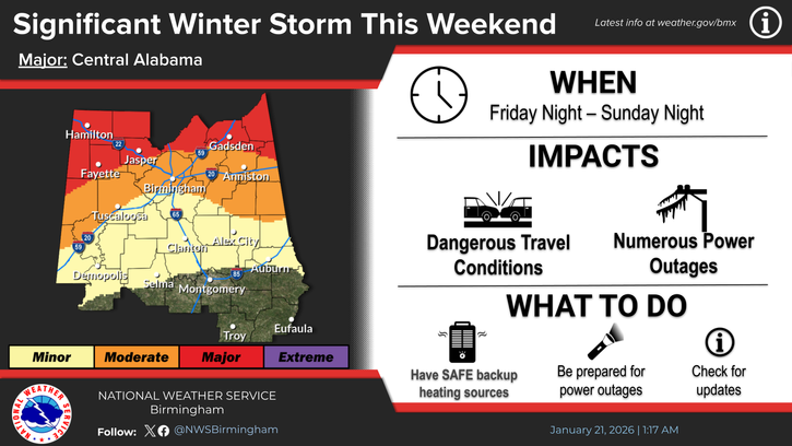
The National Weather Service office in Birmingham said Tuesday that it is monitoring a storm expected to develop late Friday and continue through Sunday night, with a mix of freezing rain, sleet, and rain possible over north and parts of central Alabama. Confidence is highest that the worst impacts will be along and north of the I-20 corridor, but forecasters caution that areas farther south in central Alabama could also see periods of freezing rain, especially at night and during the early morning hours as temperatures fall below freezing.
Exactly how far south the freezing line sets up, and how much ice accumulates, will depend on the final track of the storm and small changes in temperature — details that are still being refined.
The Weather Prediction Center’s Winter Storm Severity Index, a national National Weather Service product that estimates impacts from winter weather, already shows the potential for moderate to major travel and infrastructure impacts across the northern third of Alabama this weekend, with lighter but still possible impacts extending southward toward central counties.
For readers in Hale, Perry, and surrounding counties, this area is on the southern edge of the highest-risk zone. If the cold air pushes a little farther south than currently expected, ice totals could increase quickly. Even a thin layer of ice on bridges, trees, and power lines can make travel hazardous and trigger scattered power outages, especially if winds increase behind the system.
Forecasters also warn that very cold air will spill into the state after the storm, with lows in the teens and 20s and wind chills in the single digits possible early next week, which could prolong any power or water issues for those affected.
Local emergency managers and meteorologists are urging residents not to panic, but to prepare now in case our area ends up on the colder, icier side of the system.
That preparation starts at home:
- Have at least several days’ worth of non-perishable food, drinking water, and necessary medications on hand.
- Gather flashlights, batteries, battery packs, and extra blankets in a central, easy-to-reach place.
- Plan for how you will stay warm and sheltered if the power goes out.
The National Weather Service also recommends:
- Fuel vehicles early.
- Keep phones and other devices fully charged ahead of the storm.
- Check on neighbors, elderly relatives, and anyone who may have trouble preparing on their own.
Around the house, forecasters say it is important to:
- Trim weak or dead tree limbs that could fall on homes, driveways, or power lines.
- Protect pipes in unheated spaces by insulating them or allowing faucets to drip in exposed areas.
- Run generators outside, well away from doors and windows, to prevent carbon monoxide poisoning.
- Never use grills or gas heaters meant for outdoor use indoors.
- Ensure pets have a warm, dry place to stay and easy access to food and water.
If icy conditions develop, people are urged to stay off the roads as much as possible. If travel is absolutely necessary:
- Use extreme caution.
- Allow extra time.
- Watch for black ice on bridges and overpasses.
Because this system is still several days away and the exact track remains uncertain, the forecast will likely change as new data arrives.
As of Tuesday afternoon, the National Weather Service had not yet issued winter storm watches or warnings for our immediate area, but those could be posted later this week as confidence increases.
Residents are encouraged to monitor updates from the National Weather Service in Birmingham, local emergency management agencies, and trusted local media for the latest information.